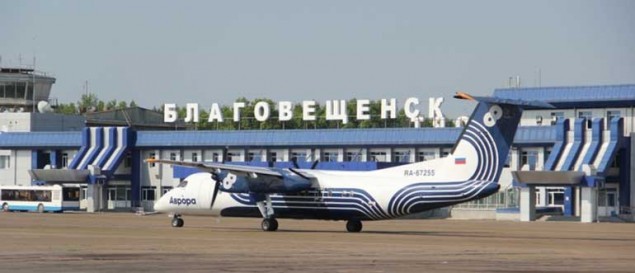

Ignatyevo Airport is an international airport in Amur Oblast, Russia, located near the village of Ignatyevo 15 kilometers north-west of Blagoveshchensk and 3,5 kilometers away from state border of Russia. The large airport services up to medium-sized airliners with parking space for 44 civilian aircraft, and conducts 24-hour flight operation. Ignatyevo Airport is state-owned by Amur Oblast and jointly operated with the Russian Air Force, with a military pad on the north-west side of the airport.

Within the Blagoveshchensk TMA altitudes below the transition level are calculated in feet according to QNH pressure
Transition altitude: 4000 feet
Transition level:
FL050 when QNH ≥ 1013 HPa
FL060 when QNH < 1013 or ≥ 977 HPa
FL070 when QNH < 977 HPa
Airport located close to state border with People's Republic of China. ATC provided by procedural tower from Ground up to FL120
| RWY | MAG BRG | Dimensions(m) | Landing system |
|---|---|---|---|
| 36/18 | 01° | 3000x45 | ILS CAT II (111.100) |
| 181° | ILS CAT I (108.700) |
| Position | Designator | Callsign | Frequency |
|---|---|---|---|
| FSS * | RU-ERC_FSS | Eastern Russia Control | 135.550 |
| Control * | UHHH_1_CTR | Khabarovsk-Control | 126.600 |
| Control | UHHH_CTR | Khabarovsk-Control | 124.500 |
| Tower * | UHBB_TWR | Blagoveshchensk-Tower | 127.200 |
| ATIS | UHBB_ATIS | Blagoveshchensk-ATIS | 126.400 |
| Title | Type | Tags | Addition time |
|---|---|---|---|
|
UHBB 2024
|
scenery | P3Dv4 P3Dv5 | 25.06.2024 |
| (no description) | |||
|
DV SCENARIOS - UHBB Blagoveshensk for MSFS |
scenery | MSFS 2020 | 20.01.2024 |
| (no description) | |||
|
UHBB NEW XP11 XP12
|
scenery | xPlane 11 | 11.01.2024 |
| (no description) | |||
|
UHBB MSFS Borat Sagdiev |
scenery | MSFS 2020 | 07.02.2021 |
| Old runway | |||
|
UHBB FS9 |
scenery | FS 9 | 03.05.2016 |
| (no description) | |||

2024 © VATRUS division
Русская версия
VATSIM –
Code of Conduct –
Устав VATRUS –
Privacy Policy